 GeoSuite Docs
Orebit GeoSuite
Offline Mineral Exploration & Resource Estimation Suite
Suite Eksplorasi Mineral & Estimasi Sumber Daya Luring


Orebit Core
Interactive Tutorial
ENStep-by-step guided tour on first launch. Covers data upload, column mapping, and all major features. Can be replayed anytime from the help button.
IDTur panduan langkah-demi-langkah saat pertama kali dibuka. Mencakup unggah data, pemetaan kolom, dan semua fitur utama. Dapat diputar ulang kapan saja dari tombol bantuan.
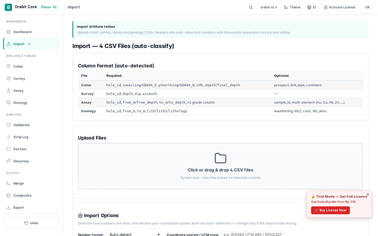
CSV Data Upload
ENDrag-and-drop or click to upload collar, survey, assay, and geology CSV files. Auto-detects column names and data types with smart mapping.
IDSeret-dan-lepas atau klik untuk mengunggah file CSV collar, survey, assay, dan geologi. Mendeteksi nama kolom dan tipe data secara otomatis.
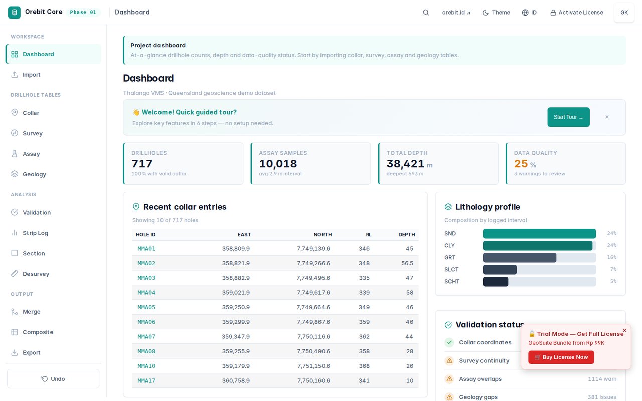
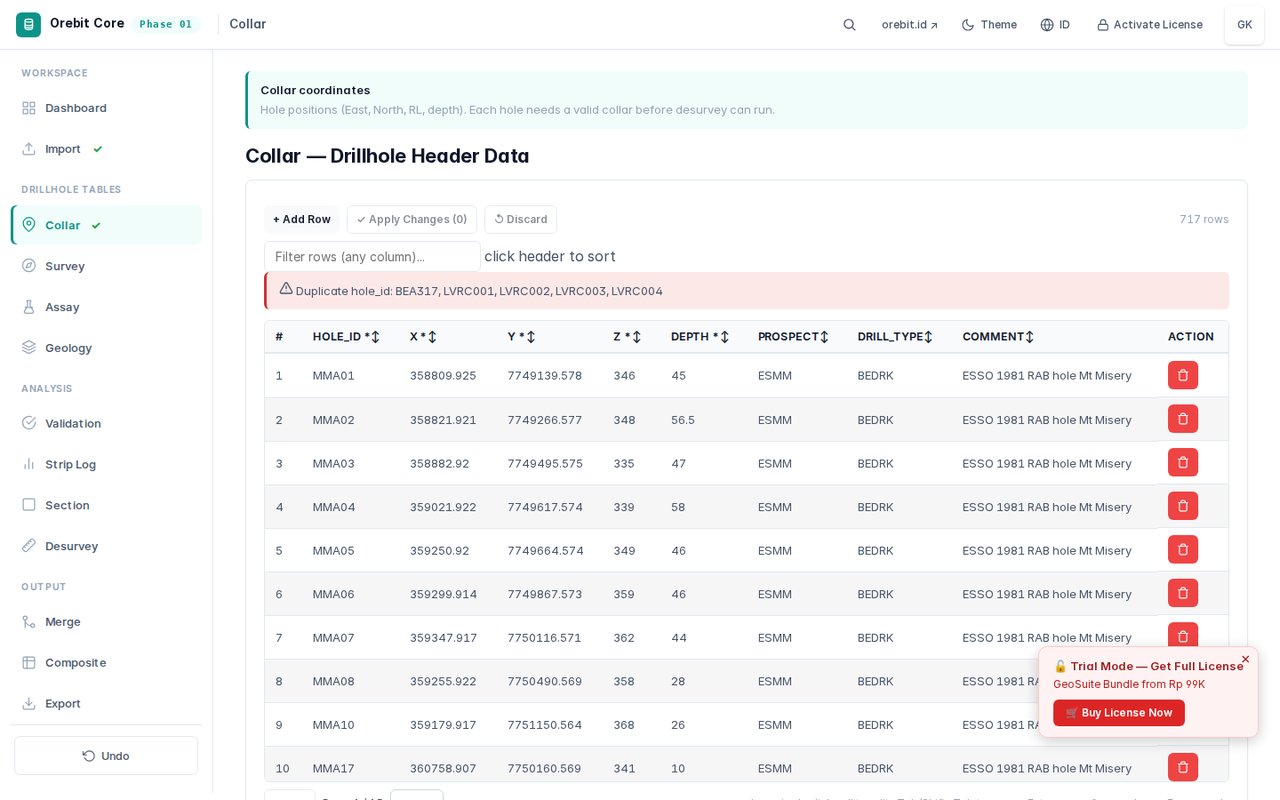
Data Table View
ENInteractive sortable table with search, filter, and column visibility controls. Supports pagination for large datasets.
IDTabel interaktif yang dapat diurutkan dengan pencarian, filter, dan kontrol visibilitas kolom. Mendukung paginasi untuk dataset besar.
Survey Data Management
ENView and validate survey measurements (azimuth, dip, depth). Highlights missing or inconsistent survey intervals.
IDLihat dan validasi pengukuran survey (azimuth, dip, kedalaman). Menyorot interval survey yang hilang atau tidak konsisten.
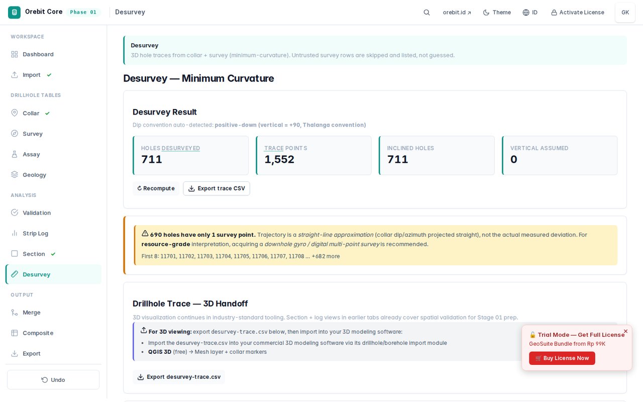
Desurvey Calculation
ENConverts survey station data into 3D coordinates using minimum curvature method. Calculates X, Y, Z at any sample depth.
IDMengkonversi data stasiun survey ke koordinat 3D menggunakan metode kurvatur minimum. Menghitung X, Y, Z pada kedalaman sampel manapun.
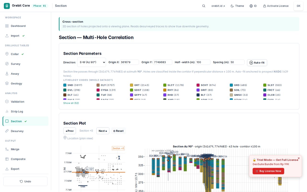
Cross-Section Visualization
ENInteractive 2D cross-section along any drillhole trace. Shows lithology, assay values, and composite intervals.
IDPenampang 2D interaktif di sepanjang jejak lubang bor manapun. Menunjukkan litologi, nilai assay, dan interval komposit.
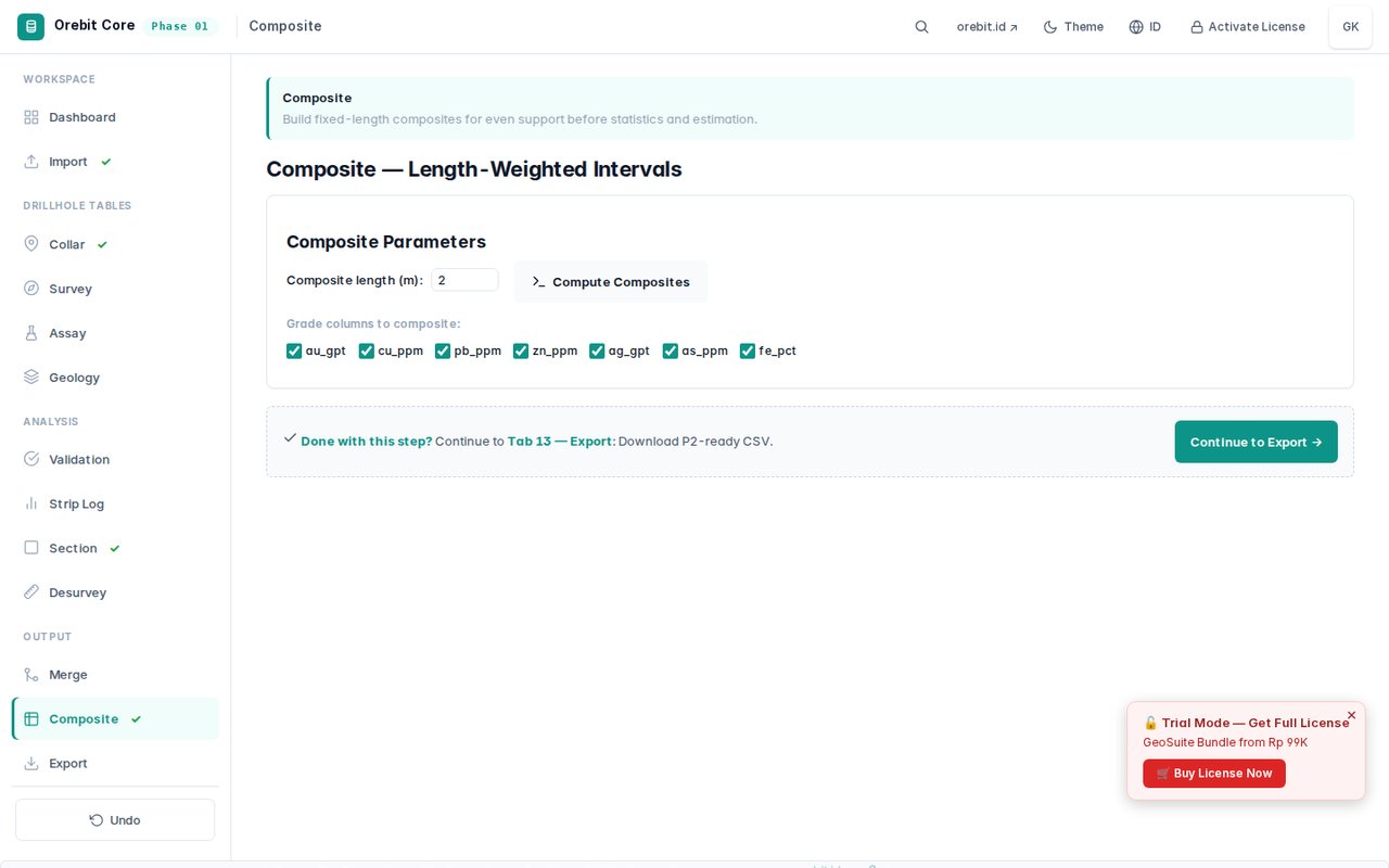
Composite Calculation
ENLength-weighted compositing with configurable interval length. Handles capping, missing data, and domain boundaries.
IDKomposit berbobot panjang dengan interval yang dapat dikonfigurasi. Menangani pembatasan, data hilang, dan batas domain.
Merge & Export
ENMerge collar, survey, assay, and geology into a single analysis-ready table. Export as CSV for Phase 2.
IDGabungkan collar, survey, assay, dan geologi ke satu tabel siap analisis. Ekspor sebagai CSV untuk Fase 2.
PDF Report
ENGenerate professional PDF report with data summary, statistics, and cross-section plots. Bilingual (EN/ID).
IDBuat laporan PDF profesional dengan ringkasan data, statistik, dan grafik penampang. Dwibahasa (EN/ID).
Orebit Assay
Interactive Tutorial
ENGuided walkthrough of EDA workflow: upload → preview → analysis → composite → domain → report.
IDPanduan langkah-demi-langkah alur EDA: unggah → pratinjau → analisis → komposit → domain → laporan.
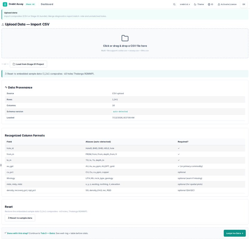
Data Upload & Preview
ENUpload composite data from Phase 1 or standalone CSV. Preview data distribution and quality before analysis.
IDUnggah data komposit dari Fase 1 atau CSV mandiri. Pratinjau distribusi dan kualitas data sebelum analisis.
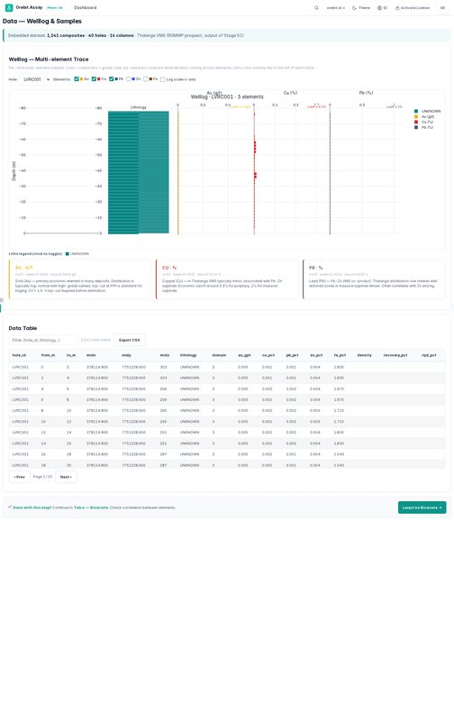
Data Preview
ENSummary statistics, missing value detection, and data type validation. Shows histogram of each numeric column.
IDStatistik ringkasan, deteksi nilai hilang, dan validasi tipe data. Menunjukkan histogram setiap kolom numerik.
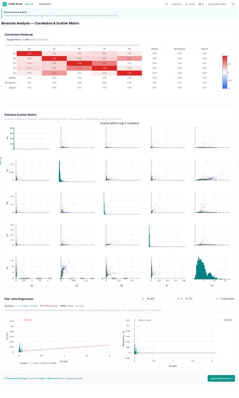
Bivariate Analysis
ENScatter plots with correlation coefficients. Supports log-scale, regression lines, and outlier highlighting.
IDDiagram sebar dengan koefisien korelasi. Mendukung skala log, garis regresi, dan penyorotan pencilan.
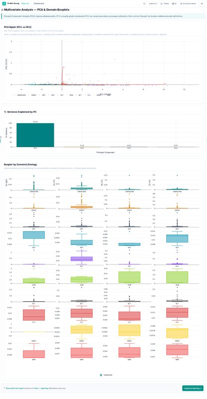
Multivariate Analysis
ENCorrelation heatmap, parallel coordinates, and PCA biplot for multi-element relationship exploration.
IDPeta korelasi, koordinat paralel, dan biplot PCA untuk eksplorasi hubungan multi-elemen.
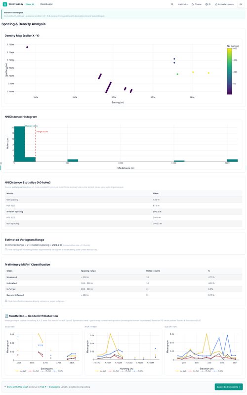
Drill Spacing Analysis
ENVariogram-based drill spacing optimization. Shows semi-variogram cloud and experimental variogram.
IDOptimasi spasi pemboran berdasarkan variogram. Menunjukkan awan semi-variogram dan variogram eksperimental.
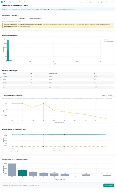
Composite Analysis
ENRe-composite with configurable interval. Shows grade distribution by composite length.
IDKomposit ulang dengan interval yang dapat dikonfigurasi. Menunjukkan distribusi grade berdasarkan panjang komposit.
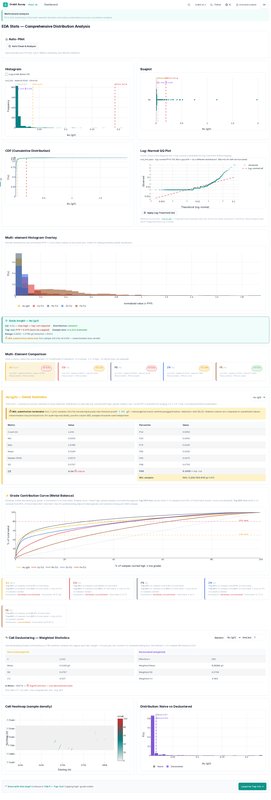
Descriptive Statistics
ENComprehensive statistics: mean, median, std dev, skewness, kurtosis, quantile table, and box plots.
IDStatistik komprehensif: rata-rata, median, deviasi standar, skewness, kurtosis, tabel kuantil, dan diagram kotak.
Top-Cut Analysis
ENOutlier detection and top-cutting using percentile, MAD, and cumulative frequency methods. Impact comparison.
IDDeteksi pencilan dan pemotongan atas menggunakan metode persentil, MAD, dan frekuensi kumulatif. Perbandingan dampak.
Lithology Analysis
ENGrade distribution by lithology. Statistical tests for lithological domain validation.
IDDistribusi grade berdasarkan litologi. Uji statistik untuk validasi domain litologi.
Domain Definition
ENDefine estimation domains based on lithology, grade ranges, or spatial boundaries. Export domain codes.
IDDefinisikan domain estimasi berdasarkan litologi, rentang grade, atau batas spasial. Ekspor kode domain.
KCMI Auto-Fill Report
ENAuto-generates KCMI/JORC compliant report sections: data quality, sampling, QAQC, and mineral resource statement.
IDBuat otomatis bagian laporan yang sesuai KCMI/JORC: kualitas data, sampling, QAQC, dan pernyataan sumber daya mineral.
Orebit Resource
Interactive Tutorial
ENGuided walkthrough of estimation workflow: setup → variography → block model → kriging → validation → report.
IDPanduan langkah-demi-langkah alur estimasi: pengaturan → variografi → model blok → kriging → validasi → laporan.
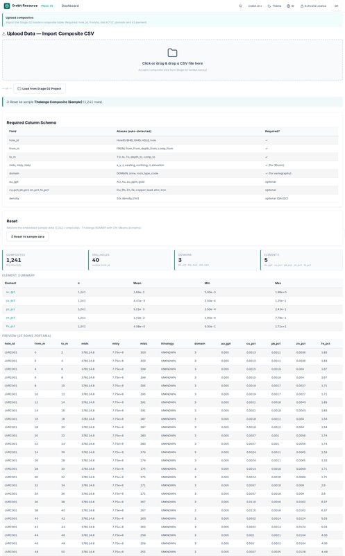
Data Upload
ENImport composite data with domain codes. Supports multiple elements for co-estimation.
IDImpor data komposit dengan kode domain. Mendukung beberapa elemen untuk ko-estimasi.
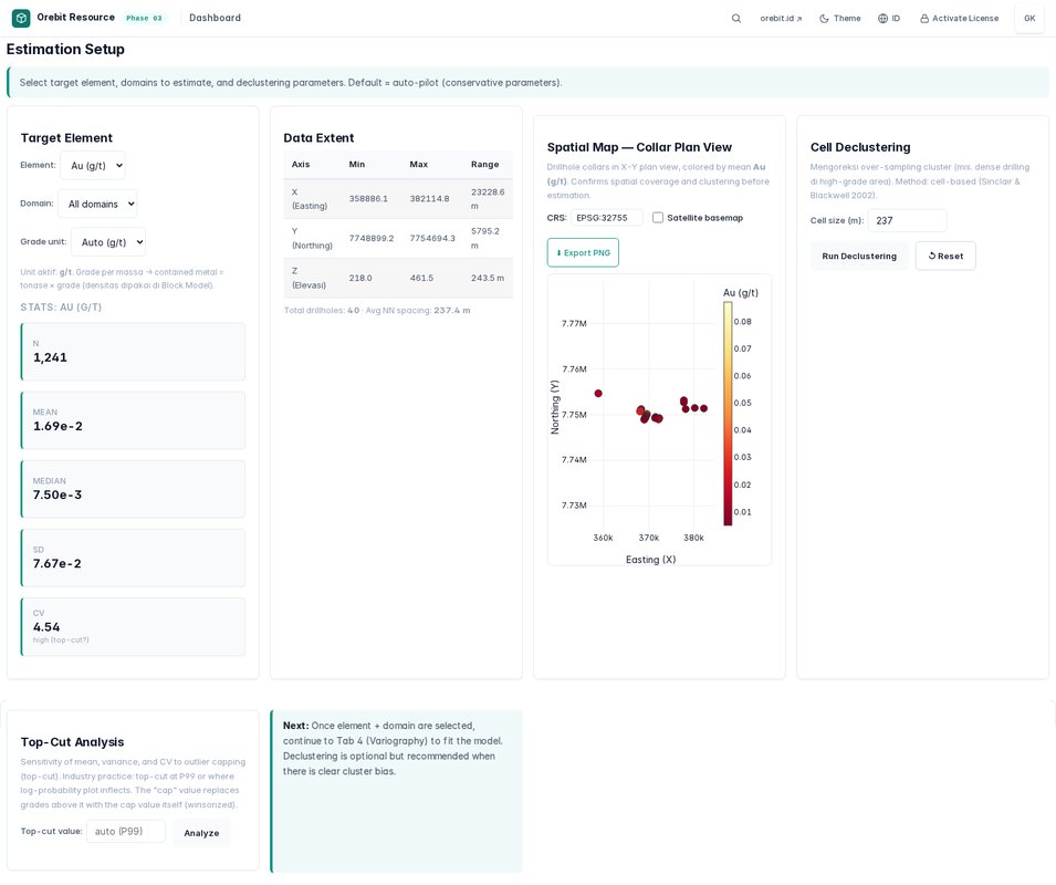
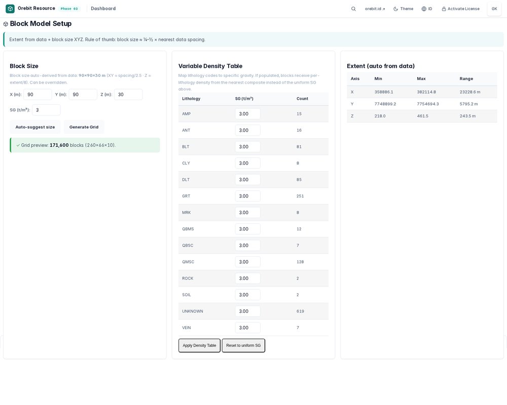
Estimation Setup
ENConfigure search parameters, kriging type (OK/SK/IDW), block size, and estimation domains.
IDKonfigurasi parameter pencarian, tipe kriging (OK/SK/IDW), ukuran blok, dan domain estimasi.
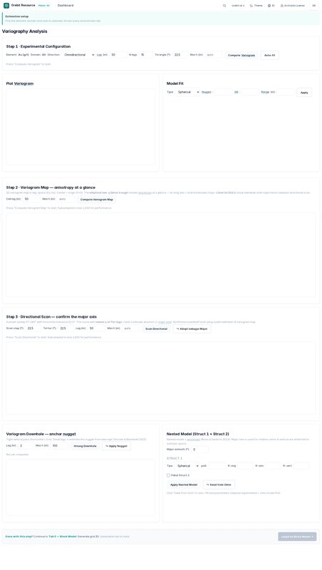
Variography
ENInteractive variogram modeling. Fit experimental variogram with nugget, spherical, and exponential models.
IDPemodelan variogram interaktif. Sesuaikan variogram eksperimental dengan model nugget, spherical, dan eksponensial.
Block Model
EN3D block model construction with parent/sub-block support. Shows block dimensions and search ellipsoid.
IDKonstruksi model blok 3D dengan dukungan blok induk/anak. Menunjukkan dimensi blok dan elipsoid pencarian.
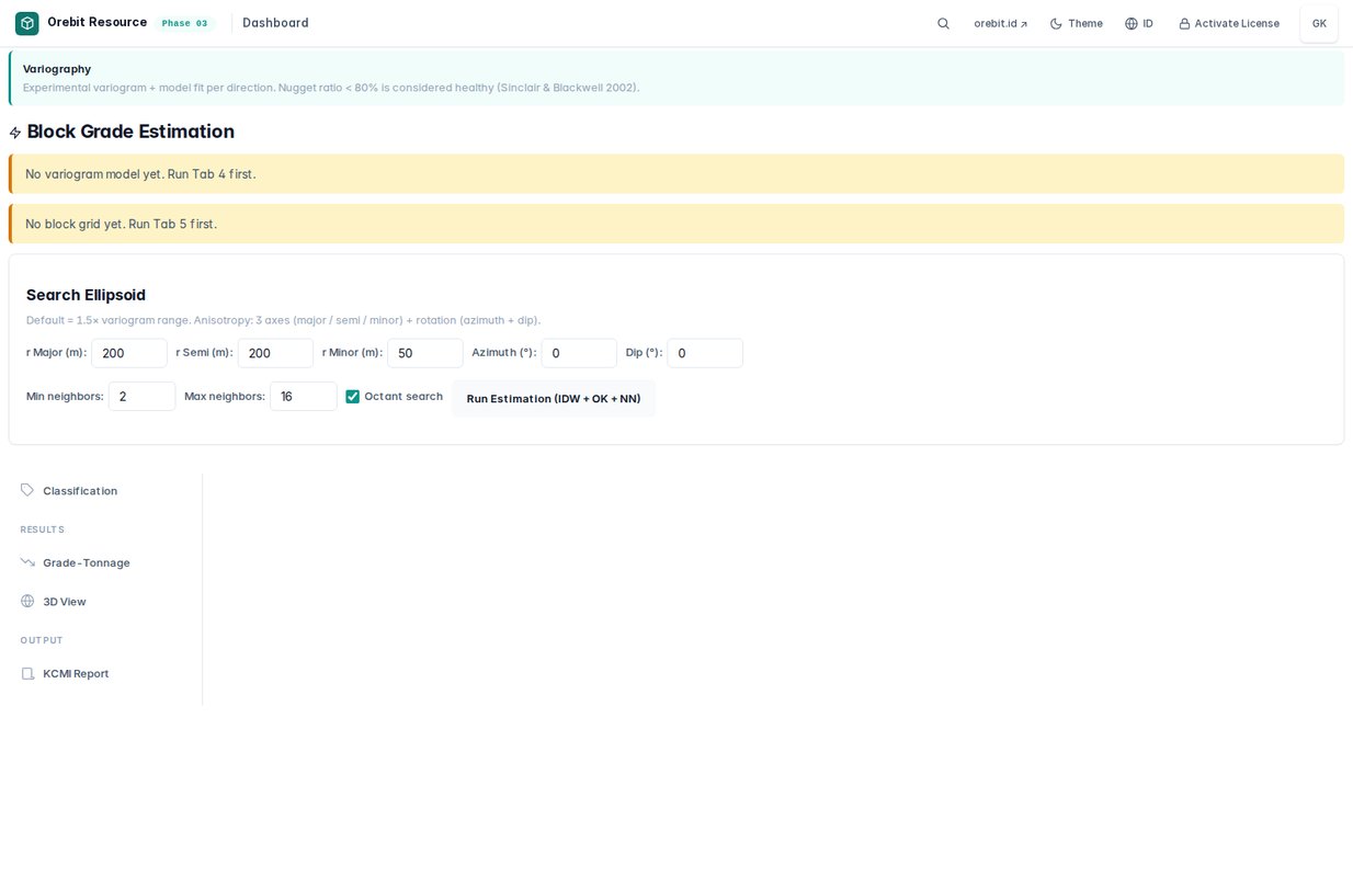
Kriging Estimation
ENOrdinary Kriging with search parameters. Shows kriging weights, estimation variance, and grade map.
IDKriging Ordiner dengan parameter pencarian. Menunjukkan bobot kriging, varian estimasi, dan peta grade.
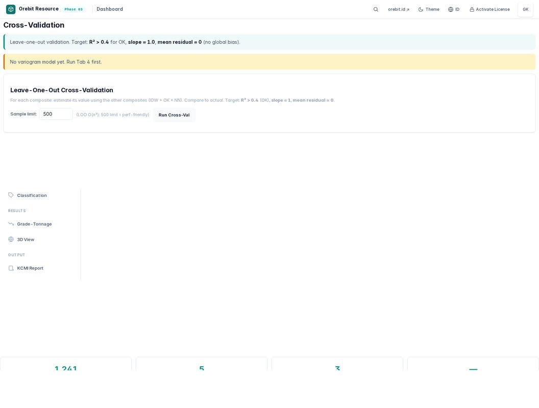
Cross-Validation
ENLeave-one-out cross-validation with scatter plot, error statistics, and kriging efficiency metrics.
IDValidasi silang leave-one-out dengan diagram sebar, statistik error, dan metrik efisiensi kriging.
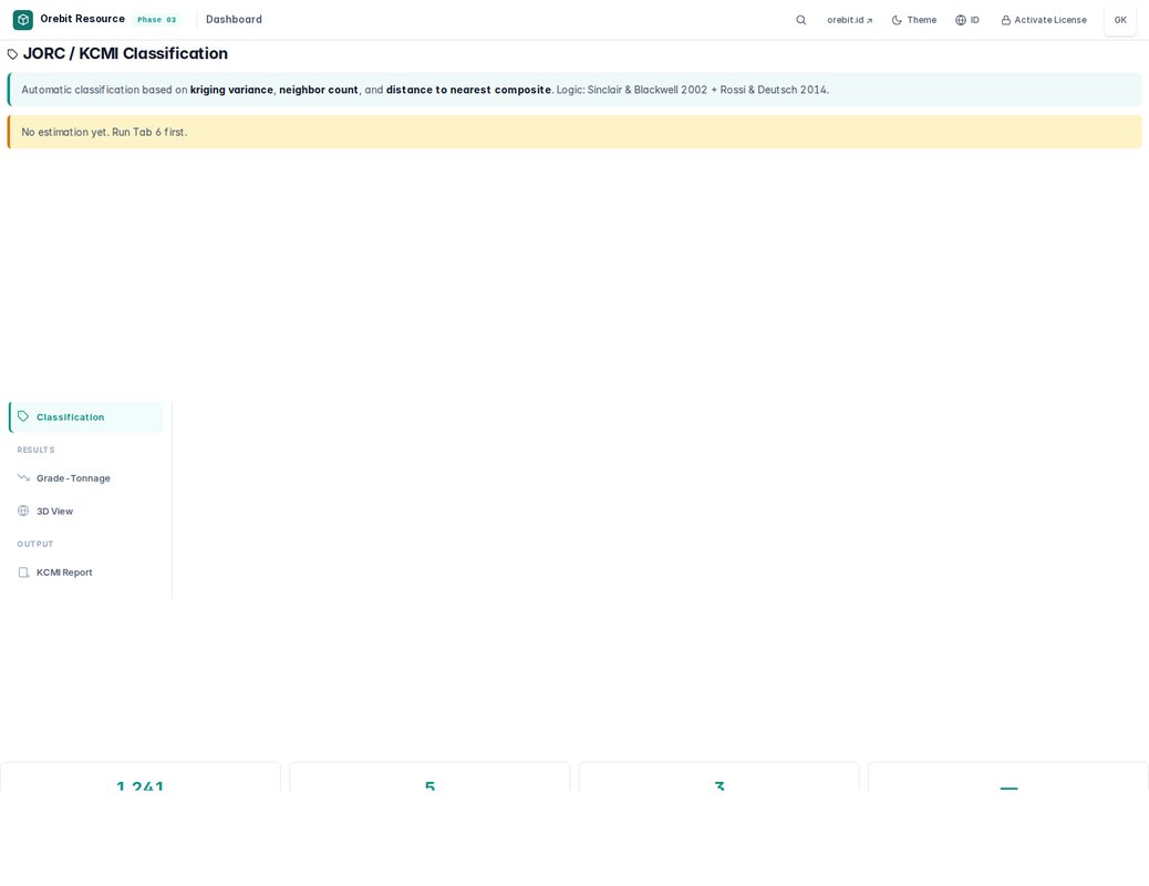
Resource Classification
ENAutomatic classification into Measured/Indicated/Inferred based on drill spacing and kriging variance.
IDKlasifikasi otomatis ke Terukur/Terindikasi/Terinferensi berdasarkan spasi pemboran dan varian kriging.
Tonnage-Grade Curve
ENCut-off grade sensitivity analysis. Shows tonnage, grade, and metal content at various cut-offs.
IDAnalisis sensitivitas grade potong. Menunjukkan tonnage, grade, dan kandungan logam pada berbagai grade potong.
3D Block Model View
ENInteractive 3D visualization of the block model with grade coloring, slice planes, and drillhole traces.
IDVisualisasi 3D interaktif model blok dengan pewarnaan grade, bidang irisan, dan jejak lubang bor.
KCMI Compliance
ENKCMI/JORC checklist auto-fill. Validates estimation methodology against Indonesian mining standards.
IDIsi otomatis checklist KCMI/JORC. Validasi metodologi estimasi terhadap standar pertambangan Indonesia.
PDF Report
ENComprehensive estimation report: variogram parameters, block model summary, resource statement, and tonnage-grade curves.
IDLaporan estimasi komprehensif: parameter variogram, ringkasan model blok, pernyataan sumber daya, dan kurva tonnage-grade.
Appendix A — System RequirementsPersyaratan Sistem
Minimum Requirements / Persyaratan Minimum
EXE Version (Windows) / Versi EXE (Windows)
ENThe EXE wrapper provides a standalone desktop experience. No browser needed. Just double-click the .exe file.
IDPembungkus EXE memberikan pengalaman desktop mandiri. Tidak perlu peramban. Cukup klik dua kali file .exe.
Data Format / Format Data
All phases use standard CSV files with the following expected columns:
Appendix B — Quick Start GuidePanduan Cepat
Step 1: Open the HTML File / Langkah 1: Buka File HTML
ENDouble-click the HTML file (e.g., Drillhole-Prep.html). It opens in your default browser. No server, no installation.
IDKlik dua kali file HTML (misal Drillhole-Prep.html). Terbuka di peramban default. Tanpa server, tanpa instalasi.
Step 2: Load Sample Data / Langkah 2: Muat Data Contoh
ENClick "Load Sample Data" on the welcome screen to explore with the included Thalanga VMS dataset (28 holes, 3,141 samples).
IDKlik "Muat Data Contoh" di layar selamat datang untuk menjelajahi dataset Thalanga VMS (28 lubang, 3.141 sampel).
Step 3: Upload Your Data / Langkah 3: Unggah Data Anda
ENClick "Upload CSV" and drag your collar, survey, assay, and geology files. Column names are auto-mapped.
IDKlik "Unggah CSV" dan seret file collar, survey, assay, dan geologi Anda. Nama kolom dipetakan otomatis.
Step 4: Navigate Tabs / Langkah 4: Navigasi Tab
ENUse the vertical sidebar on the left to switch between tabs. Each tab represents a workflow step.
IDGunakan sidebar vertikal di kiri untuk beralih antar tab. Setiap tab mewakili langkah alur kerja.
Step 5: Save Your Project / Langkah 5: Simpan Proyek
ENClick "Save Project" to save your work as an .orebit bundle. Reload it anytime to continue.
IDKlik "Simpan Proyek" untuk menyimpan pekerjaan sebagai bundel .orebit. Muat ulang kapan saja untuk melanjutkan.
Appendix C — Privacy & LicensePrivasi & Lisensi
Privacy First / Privasi Utama
- ✓ No data collection — zero analytics, zero telemetry, zero tracking✓ Tidak ada pengumpulan data — nol analitik, nol telemetri, nol pelacakan
- ✓ No server communication — all computation is client-side✓ Tidak ada komunikasi server — semua komputasi sisi klien
- ✓ No external dependencies — all libraries embedded (Plotly, jsPDF, html2canvas)✓ Tidak ada dependensi eksternal — semua pustaka tertanam
- ✓ CSP-locked — Content Security Policy blocks all external connections✓ CSP terkunci — Kebijakan Keamanan Konten memblokir semua koneksi eksternal
- ✓ Works offline — no internet connection required after download✓ Bekerja luring — tidak perlu koneksi internet setelah unduh
License / Lisensi
Version History / Riwayat Versi
— Ghozian Karami, founder @ Orebit · orebit.id
Appendix D — Online ResourcesSumber Daya Daring
All modules are delivered via email after purchase. Semua modul dikirim melalui email setelah pembelian.